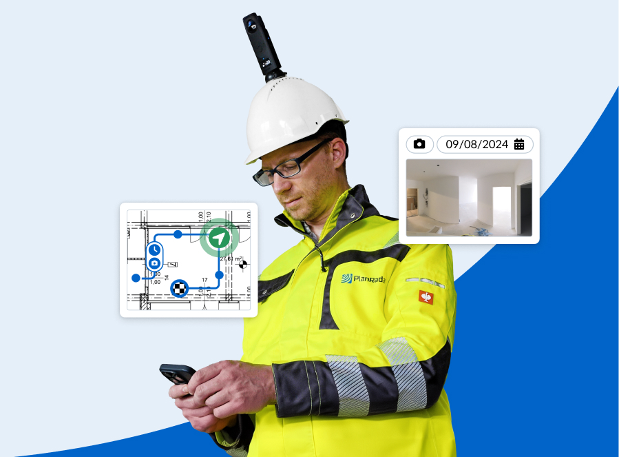
PlanRadar, the leading platform for digital documentation, communication and reporting in construction, facility management and real estate projects, introduces its new SiteView feature - previously announced in March 2024 - which captures 360° imagery of a project and maps it onto a 2D plan, creating a detailed visual record of activity in a construction site.
SiteView leverages SLAM (Simultaneous Localisation and Mapping), a technology widely used in robotics and autonomous systems to enable devices or robots to navigate unknown environments.
The Technology Behind
SLAM works by creating a map of an area while simultaneously tracking the location of the device within it. As the device moves, it uses sensors like cameras or lasers to collect data about its surroundings, identifying walls, doors, and objects to build a “picture” of the space and track its movements.
With each new data point, both the map and the device’s position within it are continuously updated, allowing the device to navigate smoothly, avoid obstacles, adapt to its environment, and capture data in real-time.
Globally, the SLAM technology market is growing rapidly, fuelled by advancements in artificial intelligence, robotics, and sensor technology. With demand for autonomous vehicles and robotics on the rise, this market is expected to reach USD 9,425.7 million by 2030 [1].
Given its potential and the rapid pace of technological advancements, SLAM is being increasingly adopted across sectors to improve efficiency and data capture quality.
Opportunity in the Construction Industry: PlanRadar SiteView
SLAM technology has started to make inroads in construction, though it has yet to reach its full potential. Traditionally, construction documentation involves manually capturing hundreds of photos or videos to track project progress.
To streamline this workflow and to add a superior level of documentation capabilities, PlanRadar developed SiteView, a feature that uses SLAM technology to automatically map 360° images of a construction site onto a 2D site plan, enabling comprehensive visual documentation with minimal effort. By simply walking the site with a camera-equipped helmet, users can capture images that automatically align with the site plan using AI and computer vision algorithms, providing precise localisation and depth estimation.
This feature provides significant benefits by adding more visual components to PlanRadar's already strong documentation capabilities. SiteView enables efficient condition surveys, quickly capturing a building's initial state and protecting companies from liability over preexisting issues. As projects progress, SiteView allows for milestone comparisons the “before and after” of the progress, even enabling users to view “behind the wall”, reducing the risk of costly rework – estimated to average 11% of total project costs [2] – by providing precise visual records for a full project transparency.
Additionally, SiteView improves team collaboration by providing remote access to real-time visual updates, enabling stakeholders to conduct faster reviews and approvals without visiting the site. This keeps clients, developers, and end-users informed throughout the project life-cycle, reducing miscommunication and preventing disputes with clear documentation of completed work.
“Our aim is to continually improve the customer experience by integrating cutting-edge technologies that make our product the best,” says Leon Ward, Regional Lead for Australia + New Zealand of PlanRadar. “SiteView enhances the powerful documentation capabilities we already offer through our digital platform, combining ease of use with the highest accuracy. With this new feature, we are making innovative technology more accessible to the construction industry, delivering sophisticated visual documentation for full transparency, reduced miscommunication, and less rework on projects.”
Future of PlanRadar SiteView
SiteView is currently available to PlanRadar's customers and potential clients. This launch marks the beginning of SiteView's development journey, with future updates planned based on user feedback and industry demand. The PlanRadar R&D team is already working on enhancing interactivity within 360° images, with planned features such as markups, tagging, bookmarking, and measurement capabilities.
Find out more about PlanRadar SiteView here.
Key Facts:
Watch the SiteView video here: https://vimeo.com/1031906084
About us:
ABOUT PLANRADAR:
PlanRadar is an award-winning, digital SaaS field management platform for documentation, task management and communication in construction, facility management and real estate projects.
The platform operates across the globe, currently in over 75 markets.
PlanRadar digitises all daily processes and communication across real estate and construction. The platform connects all project stakeholders and provides real-time access to valuable project data, enabling teams to increase quality, cut costs and realise work faster. The easy-to- use platform adds value to every person involved in a building’s lifecycle, from contractors and engineers to property managers and owners, with flexible capabilities for all company sizes and processes.
Today, over 150,000 professionals are using PlanRadar to track, connect and solve issues on- and off-site. PlanRadar is currently available in more than 25 languages, and can be used across all iOS, Windows and Android devices. Headquartered in Vienna, Austria, PlanRadar has 16 offices across the globe.
Contact: [email protected]
Website: www.planradar.com
Contact details:
Mia Hajje | Account Manager
[email protected] | +61 455 566 638
The Atticism PR & Brand Development
Sydney, Australia | London, United Kingdom
www.theatticism.com


